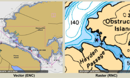
Chart plotter manufacturers such as Simrad, Garmin, Furuno, and other proprietary hardware manufacturers rely on charts from chart vendors such as Navionics, Garmin, and C-Map. The valuable information in these charts comes from NOAA for U.S. waters and from Canadian Hydrographic Service (CHS) for B.C. waters. Both NOAA and CHS routinely update their chart content and make these updates available to the third-party chart vendors to make the corresponding changes to their derivative chart products.
These proprietary chart providers get their data from NOAA and CHS to prepare, produce, and distribute their own charts. There is a delay factor since they can’t make changes until they get new data from NOAA/CHS, and then they have to go through the process of getting the new data into their database and distribute these new charts out to the boater. This means that your chart plotter is often not giving you the most current information. We have personally experienced such a delay, where our chart plotter clearly had errors; we noted changes that had not yet been reflected in the most current version of the charts. In some cases, as reported by others, the information made available by NOAA did not appear in proprietary charts on chart plotters for over six months.
Local Notices to Mariners are available for both NOAA and CHS chart corrections and are a valuable tool for following known charting changes that are in the third-party chart providers’ update process. Each edition of Local Notice to Mariners will usually include chart corrections until the change has been made to the NOAA or CHS charts. Due to the delay of third-party chart suppliers to include the latest NOAA and CHS changes for charts, you may need to keep older editions of Local Notice to Mariners until the change appears in your chart plotter charts from your third-party vendor.
NOAA and CHS Published Charts are available directly from each agency in electronic format and can be downloaded and viewed on windows or iPad devices. Freeware is available to view these charts. Coastal Explorer from Rose Point Software is a full-function Windows PC- and iPad-based charting and navigation software, which can be used to view and use the native NOAA and CHS charts. Using the native NOAA and CHS charts gives you access to the most current and up-to-date chart content and avoids any delays. Coastal Explorer automatically downloads updated charts on your computer each time the program is started.
Why Chart Plotters Don’t Use Native NOAA and CHS ENC Charts? It would be nice if chart plotter providers allowed access and use of the more current NOAA and CHS charts. The reasons for manufacturers limiting access to proprietary chart sources is likely a business arrangement decision. Technology limitations may have been an issue with the first generation of chart plotters. However, in today’s technically advanced world, technology is no longer a factor. Most likely it’s a business and profit motivated decision that prevents boaters from using the most current charts. Unfortunately, this business arrangement between chart plotter manufacturers and chart providers means there is a delay when it comes to updating their proprietary charts. In the interest of boater safety, it is hoped that future software updates for chart plotters will provide access and use of NOAA and CHS ENC/Vector charts. Until then, Coastal Explorer, with the most current charts, will be a vital part of our pilothouse navigation systems.
With Coastal Explorer you can use native NOAA/CHS charts or C-Map proprietary charts. You can also choose the option to have all of your charts dynamically updated every time you start Coastal Explorer on your computer – Windows PC or on your iPad. You can also purchase/license CHS charts through Coastal Explorer at a lower price than if you had purchased the charts directly from CHS.
NOAA’s sunsetting of raster chart products is planned to provide mariners with better chart products with faster and more frequent updates. CHS has also announced a similar strategy with raster chart products. In the future, third-party chart providers will increasingly be challenged to get the most recent charts into proprietary chart plotters. In the meantime, NOAA continues to fulfill their commitment to improve charts and to update their charts in a timely manner.
Yes, boaters still need to have proprietary chart plotters for radar and depth sounding, so we are not suggesting that you get rid of proprietary chart plotters. We do strongly suggest using multiple sources of chart information. We routinely have Coastal Explorer running on our computer side-by-side with our chart plotter; this gives us the opportunity to have two different views from two different chart providers.
