Navigation charts for Northwest waters on both sides of the border are in the midst of a major change. In 2019 NOAA announced plans to “Sunset” U.S. Raster chart products. Similarly, and with less fanfare, Canadian Hydrograph Services (CHS) activated plans to eliminate Raster charts as well. Coincident with sunsetting of raster charts, both NOAA and CHS plan to enhance ENC (Vector or Electronic Navigation) Charts.
What’s the Current Status?
NOAA is on track to sunset Raster charts. Over half of the original Raster charts have already been cancelled (see NOAA’s list of last dates – https://charts.noaa.gov/MCD/Dole.pdf. Remaining Raster charts may not be up to date, since updates are first applied to ENC charts. NOAA’s slightly revised deadline for cancelling all Raster charts is now January 2025.
Canada’s CHS is nearing the middle of their 5-year plan to transition to ENC charts and cancel Raster charts. CHS has been cancelling British Columbia Raster charts for several years, with a significant number of west coast charts now cancelled – https://www.charts.gc.ca/charts-cartes/withdrawn-retires/bsb-eng.asp. CHS has yet to announce a date for the cancellation of all Raster charts.
Where Do Cancelled Raster Charts Go?
Both NOAA and CHS cancelled Raster charts are no longer updated and will not be supported. Cancelled charts are not to be used for navigation and do not meet carriage requirements.
NOAA cancelled charts are not available for download or update. Cancelled Raster charts locally stored can still be viewed and used for reference only. If you have previously downloaded a cancelled chart, it will generally remain stored locally and will not be removed by an update process.
Canada’s CHS charts are available as individual chart products and in groups, or geographically organized packages (PAC01, PAC02, …) of individual charts. Whether purchased individually or as a package, cancelled charts are not available for download and will not be included in packages. CHS cancelled charts that are stored locally can be viewed for reference but are not valid for navigation.
Both NOAA and CHS are cancelling charts individually and not as geographically related groups. In some cases, harbor scale charts have been cancelled while leaving the Plans scale chart for the overlaying area. This means that on initial view, the area appears to be covered, but the detailed large-scale chart of a passage or harbor is missing. As more and more Raster charts are cancelled, it becomes very important to navigate with ENC (Vector) charts.
Coastal Explorer users will need to mark cancelled Raster charts to view them. Click the “Charts and Add-Ons” Settings Menu, select the desired Raster (RNC) Managed Charts list, scroll down the list to the desired “This chart has been cancelled” item, right click, and select “Include in quilt”.
Legacy ENC and Re-Schemed ENC Charts
Both NOAA and CHS are in the process of enhancing and Improving vector or ENC charts. Legacy ENCs are the original ENC charts created from paper charts. Most ENC charts in use today are Legacy ENCs. Legacy ENCs come in a wide variety of shapes, sizes, and scales. Legacy ENCs are built on an old and limited definition scheme that constrains future development.
Re-Schemed ENCs have a uniform grid format with a consistent set of scales that conform with International Hydrographic Organization standards. Re-Schemed ENCs are built on an enhanced data design that allows for much more information. Re-Schemed ENC’s are planned to carry more information beyond bathymetry, such as tide and current information.
In moving from Raster to ENC charts, both NOAA and CHS are enhancing Legacy ENCs and deploying Re-Schemed ENCs. Northwest areas of Alaska already have several areas with Re-Schemed ENCs. Inside Passage waters are still largely Legacy ENC charts.
It’s Time to Change
The sun is setting on Raster charts. It’s time to move to ENCs for navigation. Raster charts may be nice as a side reference tool but because of the holes in Raster coverage, it is unsafe to depend upon Raster charts for navigation.
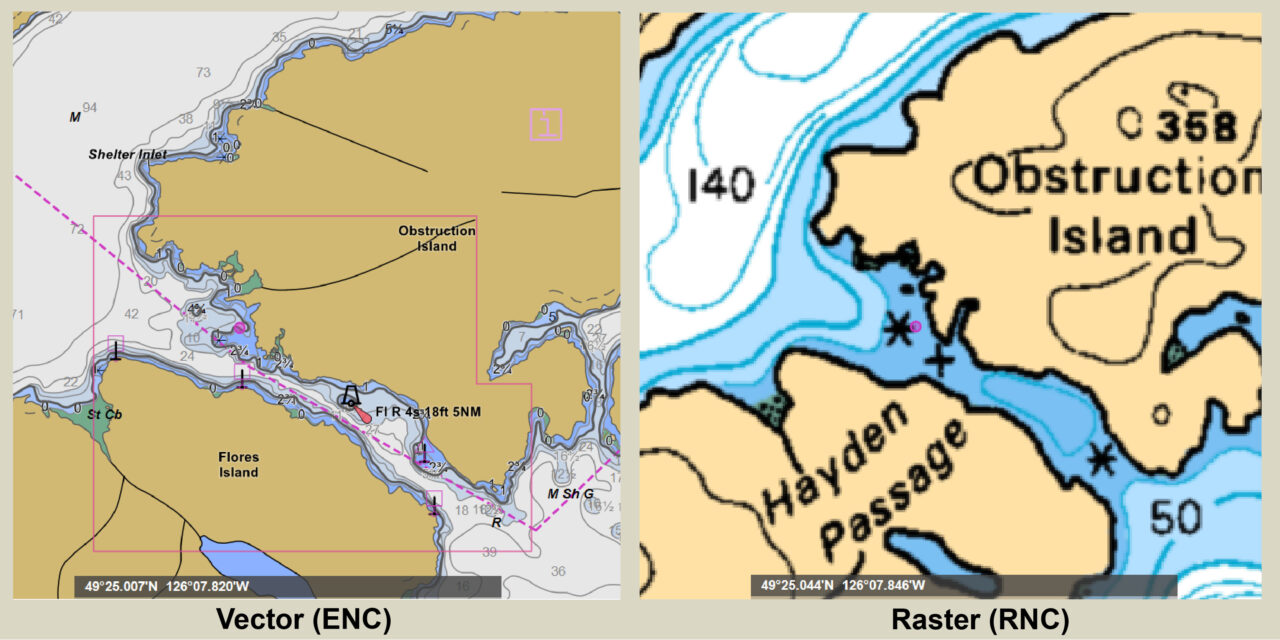
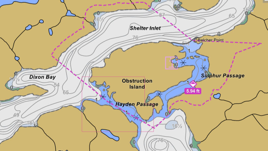
The “rocks don’t move” as an excuse for using outdated charts doesn’t work anymore. A case in point – a fellow boater recently discovered a hole in Raster coverage on West Coast Vancouver Island where the small-scale Hayden Passage chart has been cancelled, leaving only the large-scale 3603 chart with inadequate detail for safe passage.
Another case in point is the “Interim Sanctuary Zones” in the Gulf Islands that were introduced about five years ago and are depicted on the current charts. These seasonal (June – November) no-go zones are actively enforced and carry stiff penalties for violation. Older charts will not help protect a boater from violating these zones.
