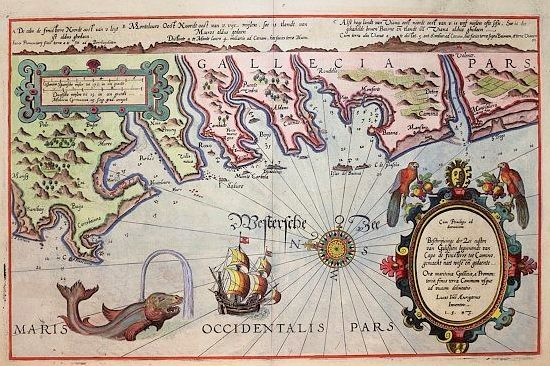
The Waggoner Name – In 1584 the Dutch pilot Lucas Janszoon Waghenaer published a volume of navigation principles, tables, charts, and sailing directions, which served as a guide for other such books for the next 200 years. These “Waggoners” as they came to be known, were very popular; and in 1588, an English translation of the original book was made. During the next 30 years, 24 editions of the book were published in Dutch, German, Latin, and English. Other authors followed the example set by Waghenaer. Soon, American, British, and French navigators had Waggoners for most of the waters they sailed.
Today’s Waggoner (pronounced wag-on-er), in honor of the Dutch pilot, is proud to carry on the respected tradition of providing first-hand knowledge, reference maps, and information to help mariners get the most out of their recreational boating adventures in the Pacific Northwest.
More about Lucas Waghenaer – Lucas was not only an expert cartographer, he was also an experienced pilot. He sailed the seas as a chief officer between 1550 and 1579. His years of sailing experience and contacts with harbour officials and seamen, provided the impetus for his chart making. The Dutch were foremost European hydrographers and cartographers of the day. Lucas Waghenaer played a major role in the early development of Dutch nautical chart-making and was one of the founding fathers of the North Holland School. After his seafaring adventures, he worked in the port of Enkhuizen as collector of maritime dues; it was here that he passed away in 1606.
Waghenaer’s published text was based on traditional navigation, but his charts added an important component, which created the world’s first published pilot guide. His charts showed coastal panoramas and land profiles as viewed from the sea. Compass intersections were used to plot prominent coastal features. Although some of these features were exaggerated, his charts were primarily intended for approaches to important harbours.
Waghenaer’s first publication, Spieghel der zeevaerdt (Mariner’s Mirror), appeared in 1584, which was a combination of nautical charts, sailing directions, and instruction for navigation on the western and north-western coastal waters of Europe; it was the first of its kind in the history of nautical cartography. A second part was published the next year and reprinted several times and translated into several languages. In 1592, his second pilot book, Thresoor der zeevaert (Treasure of Navigation) was published. His third and last publication, the Enkhuizen Sea Chart Book, was published in 1598.
Waghenaer’s publications have withstood the test of time as a model for marine guidebooks with instructions, chartletts, and piloting tips. We hope you enjoy the annually updated Waggoner Cruising Guide, published by Fine Edge Nautical Publishing based in Anacortes, Washington.
It is inconclusive or unknown if any of Waghenaer’s publications included advertising to defray his costs of printing and publication. It is noted that he died in apparent poverty, and that the municipal authorities extended his pension a year longer for his widow.
